Log in
All resources
Create a design
72 Free Artworks of 1659 Maps
bibliothèque nationale de france
tresor des cartes geographiques (1659)
maps in the rijksmuseum amsterdam
maps by willem and johannes blaeu
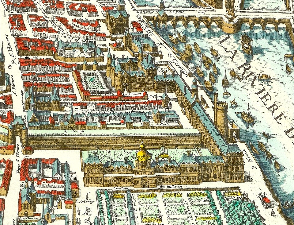
palais du louvre on old maps
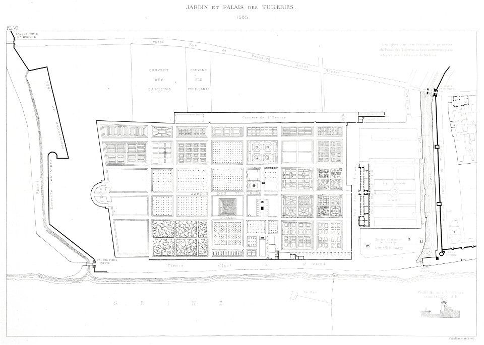
tuileries palace before 1659
merian plan of paris - derivative files
tour du bois (louvre)
maps of barbary coast by mercator-hondius
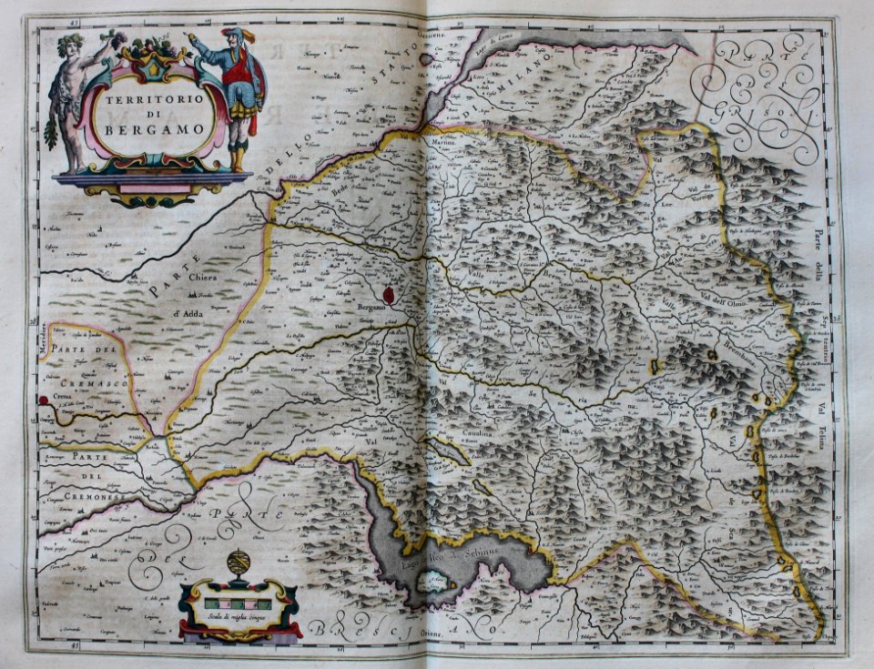
geographia blaviana
geographia blaviana
1659 maps
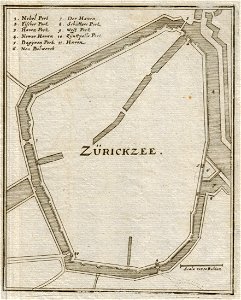
old maps of zierikzee
geographia blaviana
1659 maps
engravings by matthäus merian
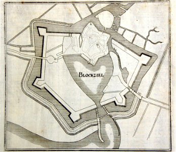
old maps of blokzijl
palais du louvre in the 1610s
palais du louvre on old maps
paris in the 16th century
lithographs of paris
historical images of église saint-germain-l'auxerrois
palais du louvre in the 1610s
tresor des cartes geographiques (1659)
old maps of the benelux
maps by willem and johannes blaeu
1659 maps
borders of andorra-france
maps of borders of spain
tresor des cartes geographiques (1659)
1650s maps of india
tresor des cartes geographiques (1659)
17th-century maps of silesia
tresor des cartes geographiques (1659)
1650s maps of the tsardom of russia
tresor des cartes geographiques (1659)
1659 maps of africa
tresor des cartes geographiques (1659)
1650s maps of eastern europe
tresor des cartes geographiques (1659)
old maps of tunis
tresor des cartes geographiques (1659)
17th-century maps of siberia
tresor des cartes geographiques (1659)
maps facing east
tresor des cartes geographiques (1659)
1650s maps of the world
tresor des cartes geographiques (1659)
1659 maps of europe
tresor des cartes geographiques (1659)
1650s maps of asia
tresor des cartes geographiques (1659)
1650s maps of turkey
tresor des cartes geographiques (1659)
1650s maps of italy
tresor des cartes geographiques (1659)
1650s maps of china
tresor des cartes geographiques (1659)
1650s maps of ethiopia
tresor des cartes geographiques (1659)
1650s maps of denmark
tresor des cartes geographiques (1659)
1650s maps of hungary
tresor des cartes geographiques (1659)
1650s maps of the americas
tresor des cartes geographiques (1659)
1650s maps of iran
tresor des cartes geographiques (1659)
1650s maps of france
tresor des cartes geographiques (1659)
1650s maps of greece
tresor des cartes geographiques (1659)
1650s maps of portugal
tresor des cartes geographiques (1659)
1650s maps of the americas
tresor des cartes geographiques (1659)
17th-century celestial maps
tresor des cartes geographiques (1659)
17th-century maps of scandinavia
tresor des cartes geographiques (1659)
17th-century maps of morocco
tresor des cartes geographiques (1659)
old maps of the whole peloponnese
tresor des cartes geographiques (1659)
maps of cyprus by mercator-hondius
maps of barbary coast by mercator-hondius
tresor des cartes geographiques (1659)
tresor des cartes geographiques (1659)
17th-century maps of the british isles
tresor des cartes geographiques (1659)
17th-century maps of morocco
tresor des cartes geographiques (1659)
maps of guinea by mercator-hondius
tresor des cartes geographiques (1659)
1650s maps of the ottoman empire
maps of candia by ortelius and mercator
tresor des cartes geographiques (1659)
17th-century maps of the malay archipelago
tresor des cartes geographiques (1659)
tresor des cartes geographiques (1659)
17th-century maps of the arctic
tresor des cartes geographiques (1659)
1650s maps of the iberian peninsula
tresor des cartes geographiques (1659)
1650s maps of the holy roman empire
maps of barbary coast by mercator-hondius
tresor des cartes geographiques (1659)
atlas of the great elector
archipelagus orientalis
maps by willem and johannes blaeu
1659 maps of europe
carte de partie de lithuanie (courland, livonia, samogitia) by nicolas sanson
cartouches by sanson family
maps by willem and johannes blaeu
copper engravings
engravings by matthäus merian
baroque
1650s maps of the world
age of discovery
tresor des cartes geographiques (1659)
bibliothèque nationale de france
tresor des cartes geographiques (1659)
bibliothèque nationale de france
tresor des cartes geographiques (1659)
bibliothèque nationale de france
tresor des cartes geographiques (1659)
bibliothèque nationale de france
old maps of the stations of the exodus
1650s maps of palestine
atlas of the great elector
archipelagus orientalis
medieval louvre
baroque
cartouches by sanson family
les forces de l'europe, asie, afrique et amerique, ou description des principales villes, avec leurs fortifications
maps in the rijksmuseum amsterdam
history prints in the rijksmuseum amsterdam
maps in the rijksmuseum amsterdam
prints by gaspar bouttats in the rijksmuseum amsterdam
maps in the rijksmuseum amsterdam
nypl collection of atlases, gazetteers, guidebooks and other books
nypl lionel pincus and princess firyal map division
maps in the rijksmuseum amsterdam
etchings of ports and harbours
paintings by heinrich hansen
1886 paintings from denmark
etchings in the rijksmuseum amsterdam
maps in the rijksmuseum amsterdam
maps in the rijksmuseum amsterdam
maps by willem and johannes blaeu
dutch 17th-century prints in the rijksmuseum amsterdam
siege of bergen-op-zoom 1622
1 - 72 of 72
/ 1


![Treasure of geographical maps of the main states of the universe [...], 1659](https://cdn.creazilla.com/illustrations/10000541161/treasure-of-geographical-maps-of-the-main-states-of-the-universe-1659-md.jpg)


![Treasure of geographical maps of the main states of the universe [...], 1659](https://cdn.creazilla.com/illustrations/10000992784/treasure-of-geographical-maps-of-the-main-states-of-the-universe-1659-md.jpg)
![Treasure of geographical maps of the main states of the universe [...], 1659](https://cdn.creazilla.com/illustrations/10000859170/treasure-of-geographical-maps-of-the-main-states-of-the-universe-1659-md.jpg)
![Treasure of geographical maps of the main states of the universe [...], 1659](https://cdn.creazilla.com/illustrations/10000302483/treasure-of-geographical-maps-of-the-main-states-of-the-universe-1659-md.jpg)
![Treasure of geographical maps of the main states of the universe [...], 1659](https://cdn.creazilla.com/illustrations/10001227179/treasure-of-geographical-maps-of-the-main-states-of-the-universe-1659-md.jpg)
![Treasure of geographical maps of the main states of the universe [...], 1659](https://cdn.creazilla.com/illustrations/10000594631/treasure-of-geographical-maps-of-the-main-states-of-the-universe-1659-md.jpg)
![Treasure of geographical maps of the main states of the universe [...], 1659](https://cdn.creazilla.com/illustrations/10000832962/treasure-of-geographical-maps-of-the-main-states-of-the-universe-1659-md.jpg)
![Treasure of geographical maps of the main states of the universe [...], 1659](https://cdn.creazilla.com/illustrations/10001176343/treasure-of-geographical-maps-of-the-main-states-of-the-universe-1659-md.jpg)
![Treasure of geographical maps of the main states of the universe [...], 1659](https://cdn.creazilla.com/illustrations/10000441201/treasure-of-geographical-maps-of-the-main-states-of-the-universe-1659-md.jpg)
![Treasure of geographical maps of the main states of the universe [...], 1659](https://cdn.creazilla.com/illustrations/10001492378/treasure-of-geographical-maps-of-the-main-states-of-the-universe-1659-md.jpg)
![Treasure of geographical maps of the main states of the universe [...], 1659](https://cdn.creazilla.com/illustrations/10001200125/treasure-of-geographical-maps-of-the-main-states-of-the-universe-1659-md.jpg)
![Treasure of geographical maps of the main states of the universe [...], 1659](https://cdn.creazilla.com/illustrations/10001176342/treasure-of-geographical-maps-of-the-main-states-of-the-universe-1659-md.jpg)
![Treasure of geographical maps of the main states of the universe [...], 1659](https://cdn.creazilla.com/illustrations/10001323164/treasure-of-geographical-maps-of-the-main-states-of-the-universe-1659-md.jpg)
![Treasure of geographical maps of the main states of the universe [...], 1659](https://cdn.creazilla.com/illustrations/10000521357/treasure-of-geographical-maps-of-the-main-states-of-the-universe-1659-md.jpg)
![Treasure of geographical maps of the main states of the universe [...], 1659](https://cdn.creazilla.com/illustrations/10000420918/treasure-of-geographical-maps-of-the-main-states-of-the-universe-1659-md.jpg)
![Treasure of geographical maps of the main states of the universe [...], 1659](https://cdn.creazilla.com/illustrations/10000449944/treasure-of-geographical-maps-of-the-main-states-of-the-universe-1659-md.jpg)
![Treasure of geographical maps of the main states of the universe [...], 1659](https://cdn.creazilla.com/illustrations/10000314824/treasure-of-geographical-maps-of-the-main-states-of-the-universe-1659-md.jpg)
![Treasure of geographical maps of the main states of the universe [...], 1659](https://cdn.creazilla.com/illustrations/10001410826/treasure-of-geographical-maps-of-the-main-states-of-the-universe-1659-md.jpg)
![Treasure of geographical maps of the main states of the universe [...], 1659](https://cdn.creazilla.com/illustrations/10001567991/treasure-of-geographical-maps-of-the-main-states-of-the-universe-1659-md.jpg)
![Treasure of geographical maps of the main states of the universe [...], 1659](https://cdn.creazilla.com/illustrations/10000659025/treasure-of-geographical-maps-of-the-main-states-of-the-universe-1659-md.jpg)
![Treasure of geographical maps of the main states of the universe [...], 1659](https://cdn.creazilla.com/illustrations/10001054877/treasure-of-geographical-maps-of-the-main-states-of-the-universe-1659-md.jpg)
![Treasure of geographical maps of the main states of the universe [...], 1659](https://cdn.creazilla.com/illustrations/10001292785/treasure-of-geographical-maps-of-the-main-states-of-the-universe-1659-md.jpg)
![Treasure of geographical maps of the main states of the universe [...], 1659](https://cdn.creazilla.com/illustrations/10000360844/treasure-of-geographical-maps-of-the-main-states-of-the-universe-1659-md.jpg)
![Treasure of geographical maps of the main states of the universe [...], 1659](https://cdn.creazilla.com/illustrations/10000397491/treasure-of-geographical-maps-of-the-main-states-of-the-universe-1659-md.jpg)
![Treasure of geographical maps of the main states of the universe [...], 1659](https://cdn.creazilla.com/illustrations/10000284064/treasure-of-geographical-maps-of-the-main-states-of-the-universe-1659-md.jpg)
![Treasure of geographical maps of the main states of the universe [...], 1659](https://cdn.creazilla.com/illustrations/10000436833/treasure-of-geographical-maps-of-the-main-states-of-the-universe-1659-md.jpg)
![Treasure of geographical maps of the main states of the universe [...], 1659](https://cdn.creazilla.com/illustrations/10000171002/treasure-of-geographical-maps-of-the-main-states-of-the-universe-1659-md.jpg)
![Treasure of geographical maps of the main states of the universe [...], 1659](https://cdn.creazilla.com/illustrations/10000206928/treasure-of-geographical-maps-of-the-main-states-of-the-universe-1659-md.jpg)
![Treasure of geographical maps of the main states of the universe [...], 1659](https://cdn.creazilla.com/illustrations/10000589616/treasure-of-geographical-maps-of-the-main-states-of-the-universe-1659-md.jpg)
![Treasure of geographical maps of the main states of the universe [...], 1659](https://cdn.creazilla.com/illustrations/10000572901/treasure-of-geographical-maps-of-the-main-states-of-the-universe-1659-md.jpg)
![Treasure of geographical maps of the main states of the universe [...], 1659](https://cdn.creazilla.com/illustrations/10001373480/treasure-of-geographical-maps-of-the-main-states-of-the-universe-1659-md.jpg)
![Treasure of geographical maps of the main states of the universe [...], 1659](https://cdn.creazilla.com/illustrations/10000859165/treasure-of-geographical-maps-of-the-main-states-of-the-universe-1659-md.jpg)
![Treasure of geographical maps of the main states of the universe [...], 1659](https://cdn.creazilla.com/illustrations/10000271069/treasure-of-geographical-maps-of-the-main-states-of-the-universe-1659-md.jpg)
![Treasure of geographical maps of the main states of the universe [...], 1659](https://cdn.creazilla.com/illustrations/10000550553/treasure-of-geographical-maps-of-the-main-states-of-the-universe-1659-md.jpg)
![Treasure of geographical maps of the main states of the universe [...], 1659](https://cdn.creazilla.com/illustrations/10000760159/treasure-of-geographical-maps-of-the-main-states-of-the-universe-1659-md.jpg)
![Treasure of geographical maps of the main states of the universe [...], 1659](https://cdn.creazilla.com/illustrations/10000757788/treasure-of-geographical-maps-of-the-main-states-of-the-universe-1659-md.jpg)
![Treasure of geographical maps of the main states of the universe [...], 1659](https://cdn.creazilla.com/illustrations/10001044907/treasure-of-geographical-maps-of-the-main-states-of-the-universe-1659-md.jpg)
![Treasure of geographical maps of the main states of the universe [...], 1659](https://cdn.creazilla.com/illustrations/10000485227/treasure-of-geographical-maps-of-the-main-states-of-the-universe-1659-md.jpg)
![Treasure of geographical maps of the main states of the universe [...], 1659](https://cdn.creazilla.com/illustrations/10001567990/treasure-of-geographical-maps-of-the-main-states-of-the-universe-1659-md.jpg)
![Treasure of geographical maps of the main states of the universe [...], 1659](https://cdn.creazilla.com/illustrations/10001596623/treasure-of-geographical-maps-of-the-main-states-of-the-universe-1659-md.jpg)


![Treasure of geographical maps of the main states of the universe [...], 1659](https://cdn.creazilla.com/illustrations/10000714295/treasure-of-geographical-maps-of-the-main-states-of-the-universe-1659-sm.webp)
![Treasure of geographical maps of the main states of the universe [...], 1659](https://cdn.creazilla.com/illustrations/10000868471/treasure-of-geographical-maps-of-the-main-states-of-the-universe-1659-lg.jpg)
![Treasure of geographical maps of the main states of the universe [...], 1659](https://cdn.creazilla.com/illustrations/10000612015/treasure-of-geographical-maps-of-the-main-states-of-the-universe-1659-md.jpg)
![Treasure of geographical maps of the main states of the universe [...], 1659](https://cdn.creazilla.com/illustrations/10000169261/treasure-of-geographical-maps-of-the-main-states-of-the-universe-1659-md.jpg)


